Species names in all available languages
| Language | Common name |
|---|---|
| Bulgarian | Синьоглав виреон |
| Catalan | vireó capblau |
| Czech | zelenáček brýlový |
| Dutch | Brilvireo |
| English | Blue-headed Vireo |
| English (United States) | Blue-headed Vireo |
| French | Viréo à tête bleue |
| French (France) | Viréo à tête bleue |
| German | Graukopfvireo |
| Hungarian | Remete lombgébics |
| Icelandic | Fjallagræningi |
| Japanese | フタスジモズモドキ |
| Norwegian | eremittvireo |
| Polish | wireonek siwy |
| Russian | Сероголовый виреон |
| Serbian | Plavoglavi zelenić |
| Slovak | vireo sivohlavý |
| Spanish | Vireo Solitario |
| Spanish (Costa Rica) | Vireo Solitario |
| Spanish (Cuba) | Verdón de cabeza gris |
| Spanish (Honduras) | Vireo Cabeza Azul |
| Spanish (Mexico) | Vireo Anteojillo |
| Spanish (Panama) | Vireo Cabeciazul |
| Spanish (Spain) | Vireo solitario |
| Swedish | glasögonvireo |
| Turkish | Mavi Başlı Vireo |
| Ukrainian | Віреон сизоголовий |
Vireo solitarius (Wilson, 1810)
Definitions
- VIREO
- vireo
- solitaria / solitaris / solitarius
The Key to Scientific Names
Legend Overview
Blue-headed Vireo Vireo solitarius Scientific name definitions
Version: 1.0 — Published March 4, 2020
Text last updated January 10, 2014
Distribution
Introduction
Breeding Range
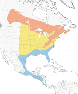
Figure 1. Northern limits of breeding include se. Yukon (potentially - species present but not recorded breeding; Sinclair et al. 2003), s. NW Territories (Sass and Buffalo rivers; Godfrey 1986), central Saskatchewan (Smith 1996), n.-central Manitoba (http://www.birdatlas.mb.ca/mbdata/maps.jsp?lang=en), n. Ontario (Northern Shield and Hudson Bay Lowlands; James 2007), central Quebec (north to ca. 51°N) and east to Anticosti I. (Todd 1963; Langevin and Lafontaine 1996), sw. Newfoundland (Warkentin and Newton 2009) and the n. Maritime Provinces (http://www.mba-aom.ca/jsp/map.jsp).
Breeding range extends west to include areas in ne. British Columbia east of the Rocky Mtns. (Campbell et al. 1997b) and south to sw. and e.-central Alberta (Semenchuk 1992); w.-central and se. Saskatchewan (Smith 1996b); se. Manitoba (see above); ne. Minnesota; n. Wisconsin (http://www.uwgb.edu/birds/wbba/species/maps/BHVI.htm); and Upper Peninsula and (locally) in Lower Peninsula of Michigan (http://www.mibirdatlas.org/Portals/12/MBA2010/BHVIaccount.pdf).
Also found locally in southernmost Ontario (http://www.birdsontario.org/atlas/maps.jsp); extreme ne. Ohio (Ohio Breeding Bird Atlas); Pennsylvania (all except southeastern and southwestern counties; Morton 2012 ); nw. New Jersey (Highlands and Kittatinny Mtns.; Walsh et al. 1999); New York State, except southeast (and Long I.), Lake Plain and Mohawk Valley (http://www.dec.ny.gov/cfmx/extapps/bba/bbaMaps.cfm?bndcode=BHVI&order=2&year=2000&comp=0); s. Connecticut, excluding Connecticut River valley (Bevier 1994d); w. Rhode Island (Enser 1992); western and central Massachusetts (Veit and Petersen 1993; http://www.pwrc.usgs.gov/bba/index.cfm?fa=explore.ResultsSummary&BBA_ID=MA2007); and extreme s. Maine (Adamus 1987).
Breeding range extends south from Pennsylvania through the Appalachian Mtns. of w. Maryland (Ellison 2010), e. and sw. West Virginia (Buckelew and Hall 1994), w. Virginia (eBird data), se. Kentucky (Palmer-Ball 1996), e. Tennessee (Nicholson 1997b), w. North Carolina (Potter et al. 1980, eBird data), nw. South Carolina (http://www.dnr.sc.gov/wildlife/bbatlas/bba.html), and n. Georgia (with recent expansion into the southern Piedmont: n.-central Georgia; Keyes 2010).
Winter Range
{Figure 1, Figure 6}. Winters from extreme se. Virginia, e. North Carolina, eastern half of S. Carolina, central Georgia, central Alabama, central Mississippi, central Louisiana, extreme se. Arkansas, se. and w.-central Texas, south to s. Florida, the Gulf Coast, and Mexico (Oberholser 1974, Potter et al. 1980, James and Neal 1986, Root 1988b, Hamel 1992, McNair and Post 1993b, Stevenson and Anderson 1994b). Highest early winter concentrations in the USA are along the Gulf Coast, n. Florida to Louisiana (see Fig. 7).
Range extends south through e. and s. Mexico, mainly on Gulf slope mountains, in e. Coahuila, Nuevo León, Tamaulipas, e. San Luis Potosí, e. Hidalgo, Tlaxcala, Puebla, and Veracruz; in Oaxaca and Chiapas, including the Pacific slope, west into Guerrero (Phillips 1991, Howell and Webb 1995); highlands of s. Guatemala, s. Honduras, El Salvador, to nw. Nicaragua (Dickey and van Rossem 1938, Monroe 1968, Land 1970, Phillips 1991, Howell and Webb 1995). Range along the Pacific slope of Mexico and Central America excludes the immediate coast (Howell and Webb 1995). Rare in w. Cuba and Isle of Pines (Garrido and García Montaña 1975), and rare in the U.S. north of se. Virginia.
Extralimital Records
Casual in the Bahamas, Jamaica (Arendt 1992), Costa Rica, Panama (Wetmore et al. 1984, Ridgely and Gwynne 1989, Stiles and Skutch 1989), and s. Mexico in Michoacán, Morelos, and Yucatán Peninsula (Howell and Webb 1995).
Historical Changes to the Distribution
In the 19th century, probably disappeared from many areas adjacent to its present range following extensive forest-clearing in se. Canada and the e. U.S. Now moving back into reforested areas in Wisconsin (Harriman 2006), n. Illinois (Kleen et al. 2004), s. Michigan (Brewer et al. 1991), s. Ontario (James 2007), nw. and se. Ohio (Peterjohn and Rice 1991), Pennsylvania (Wilson et al. 2012), NY State (especially higher elevations; McGowan 2008), n.-central Georgia (Keyes 2010), central S. Carolina (McNair and Post 1993b), and probably elsewhere.
- Year-round
- Migration
- Breeding
- Non-Breeding

eBird Status and Trends